Nerissa Goedhardt

Nerissa Goedhart

5 ways public safety agencies are already using drones today

Belgian Police officer and drone pilot reviewing footage on a controller beside a police van during a field deployment.

Drone as First Responder programmes are often talked about as something on the horizon. For a growing number of public safety agencies, they are already routine. Here are five ways drones are being used in live operations right now, with real examples from agencies running them at scale.

1. Cutting response times below 90 seconds

Dubai Police built its Drone as First Responder programme around a single target: reaching any incident scene in under 90 seconds, faster than traffic and urban density would normally allow a ground unit to arrive. Emergency calls trigger the nearest drone automatically from a fixed dock, sending live video to the command centre before officers reach the scene. The programme now runs response times as low as 1 minute and 25 seconds, with more than 25 operators coordinating missions through a single interface. You can read the full Dubai Police case study for more detail.

2. Coordinating hundreds of pilots across a national wildfire response

Portugal's Bombeiros run one of Europe's largest public safety drone networks, with more than 700 pilots spread across regions and agencies handling wildfires inland and search and rescue missions along the coast. Bringing that many pilots and drone fleets under one system means thermal feeds from a fire front can reach a command centre in real time, and pilot certifications and maintenance records stay current across hundreds of decentralised teams rather than sitting in separate local systems. As Pedro Tavares, Head of Drone Trainings and Operations at the Escola Nacional de Bombeiros, puts it: "With AirHub, we have a single, secure platform to coordinate hundreds of drone teams across different regions and agencies, whether it's wildfires inland or maritime rescues along the coast." Read the Bombeiros Portugal case study for the full picture.

3. Running multiple drones on one target during a manhunt

A single drone feed only tells part of the story during a pursuit or a large-scale search. The Belgian Police use a layered approach: one drone holds a high-precision zoom on a target while a second maintains a wider overview, with both feeds and flight paths visible to the same command centre at once. That combination has directly contributed to the recovery of missing persons and the apprehension of suspects during live operations. Bram Schoors, Chief Inspector and Drone Pilot at the Federal Police Belgium, describes the outcome plainly: "We have already been able to find two missing persons alive and well thanks to the deployment of the drone via the platform." Kristof van den Broeck, First Inspector, adds that having one platform for the whole workflow matters as much as the flight itself: "The streamed images all converge in one place, and we have a perfect overview afterwards through the log data." See the Belgian Police case study for the details.

4. Giving commanders a live overview during large events

Crowd monitoring is one of the more established public safety uses of drones: a wide aerial view over a stadium, a march or a public gathering gives commanders a perspective ground teams cannot get on their own. Rather than relying on radio reports from officers positioned around a venue, a command centre can watch density build in real time and redirect resources to a specific entrance, exit or pressure point before it becomes a safety issue. The same live feed can be shared with partner agencies working the same event, fire services, medical teams, transport authorities, so everyone involved in keeping an event safe is working from the same picture rather than relaying information second-hand. During multi-day events, that overview also helps commanders plan the next shift's deployment based on what actually happened, rather than what was reported after the fact.

5. Supporting search and rescue at sea and on the coast

Coastal and maritime search and rescue benefits from exactly the combination that makes drones useful elsewhere: fast deployment, a wide search area covered quickly, and thermal imaging that can pick out a person in the water long before a vessel or a ground team would spot them. A drone can be airborne and scanning a stretch of coastline in the time it takes a boat to leave harbour, and thermal cameras keep working after dark or in poor visibility, when the odds for someone in the water fall fastest. Coordinating that with coastguard and lifeboat crews on the water, so the drone feeds directly into the wider response, is what turns a faster search into a faster rescue. The Dutch KNRM, the national sea rescue service, uses drones exactly this way, and you can read how it works in practice in making search and rescue missions more efficient. It is part of why coastal agencies increasingly treat drones as a standard part of the response.

What these have in common

None of these examples are pilot projects anymore. They are operational programmes running every day, at a scale that depends on the same underlying requirements: fast deployment, live video that reaches the right people immediately, and a system that can manage hundreds of pilots and mixed drone fleets without adding administrative weight to every mission.

That is the same foundation AirHub is built on. The platform covers the full mission lifecycle, planning, flying, logging and managing a fleet, hardware agnostic across drone brands and docks rather than tied to a single manufacturer, and built and hosted in Europe. Live video and telemetry reach a command centre through the Drone Operations Center, with automated flight logging and compliance running in the background rather than as separate admin. It is the same platform behind Dubai Police's sub-90 second response times, Bombeiros Portugal's 700-plus pilot network, and the Belgian Police operations described above, for public safety teams working at very different scales.

Ready to see AirHub in action?

Book a demo and find out.

Related articles

The AirHub team flying a DJI drone

Content

A Reality Check: The Road Ahead for the Drone Industry

With the entry into force of the U-space regulation last month, a big step has been taken in the rapidly developing drone industry. But is U-space the one-size-fits-all solution that this industry needs? For me, the short-term answer is "No." There are still many challenges that need to be addressed before we can deploy drones at scale and reap the associated economic and social benefits. Let me highlight a few.


1. Harmonised regulations

With the introduction of the European Aviation Safety Agency (EASA) regulations for Unmanned Aircraft Systems (UAS) on December 31, 2020, the aim was to harmonise drone regulations across the European Union and make it easier for companies to incorporate drones into their workflows. And although I am a big fan of the EASA regulations, these goals have not been achieved yet.

The EASA framework has divided UAS operations into the Open, Specific, and Certified Categories. This division provides a good approach, where low-risk operations are in the Open Category with clear rules and limitations and high-risk operations are in the Certified Category, with regulations similar to those for manned aircraft and clear requirements and limitations. The issue lies with the Specific Category, where UAS operations with the greatest expected social and economic benefits take place.

The Specific Operations Risk Assessment (SORA) was introduced within this category to assess the risk of a certain type of operation and determine the requirements for pilots, aircrafts, and organizations to perform safe operations. Although SORA is a great tool, it is complicated for companies without experience in the aviation industry or other high-risk industries to use, and it is still under development, with many standards and recommended practices missing.

The lack of these standards and recommended practices results in a broad range of interpretations among European Civil Aviation Authorities (CAAs). This starts with the required content of the Concept of Operations (ConOps) and extends to the interpretation of the Ground Risk Class (a harbour in Belgium is considered a populated area, while in the Netherlands it is sparsely populated), the classification of the Air Risk Class (what constitutes Atypical Airspace?), the necessary mitigations to reduce the ARC for BVLOS (beyond visual line-of-sight) operations, and the requirements for containment to prevent drones from entering adjacent airspace or ground areas.

These gray areas make it difficult for UAS operators to apply SORA ''correctly'' and for CAAs to approve operations in a uniform and efficient manner, leading to long processing times for Operational Authorisations. This issue also affects the process of obtaining cross-border authorisations. The goal of the EASA regulations was to create an equal playing field for drone operations in Europe, allowing operators to easily perform their operations in all Member States. However, this is not the reality, as UAS operators applying for cross-border authorization encounter the same issues with interpretation differences among CAAs, resulting in delayed or cancelled operations due to high costs (i.e.,it is cheaper to hire a "local guy").

Person wearing a jacket with the AirHub logo standing outside while looking at a drone in the sky


2. Licenses and certificates

The adoption of drone technology across industries, from first responders to large enterprises in oil and gas, construction, and utilities, has been impressive. Organisations often begin with a small proof of concept and then quickly scale up their drone teams, exploring the possibilities for more sophisticated drone operations in urban areas and over long distances. To carry out these operations, organisations will require highly skilled and experienced drone pilots. However, it can be difficult to ensure that you hire a competent drone pilot. In manned aviation, there is a clear system in place with approved training organisations that educate pilots for various types of flight operations, from recreational single-engine flights to airline operations. These pilots undergo standardised exams for their basic licenses and specific aircraft and operation ratings.

In the Specific Category, this system is still lacking. It is challenging for pilots to showcase their qualifications and experience, especially with the wide range of Specific Assurance and Integrity Levels (SAIL), Standard Scenarios (STS), and Pre-Defined Risk Assessments (PDRA). It is difficult to determine the type and content of education and training required, the skill level needed to pass exams (if they exist), and to obtain a European-wide recognised license with the correct ratings.

A similar situation exists with the airworthiness requirements for drones that can be operated within the Specific Category. Operations in the lower risk categories (SAIL I and II) only require the operator to declare the airworthiness of the drone, while operations in the medium risk categories (SAIL III and IV) require a Design Verification Report (DVR) from EASA.

A DVR requirement is not a bad idea, especially for operations that could be conducted within these SAIL levels. However, many standards and acceptable means of compliance are still missing or unattainable for drone operators. Obtaining a DVR requires a large amount of data and information about the aircraft's design and fabrication, ground control station, and operating systems and services, which is often not available from the manufacturer. Additionally, the process of obtaining a DVR from EASA is lengthy and expensive.

Moreover, a DVR is only applicable for one type of operation (ConOps), making it unattractive, especially for small manufacturers, to start the process of obtaining a DVR for their aircraft. Currently, the largest drone manufacturer does not have any drones for which a DVR has been issued, making it impossible for UAS operators to obtain the required data and information or perform the large amount of necessary flight tests, and thus making it impossible for them to carry out more complex operations.


3. Business case

As mentioned, the introduction of U-space will be a big step towards enabling the safe and efficient integration of large amounts of drone flights within our lower airspace. However, for today's operations, mainly performed manually and within the visual line of sight (VLOS) of at least one remote pilot and often an additional observer or observers, U-space will not be a necessity. If we "want" large amounts of drone flights to become a reality, this must make sense from an economic and social perspective.

To achieve this, we will need - at least - a few things: BVLOS operations, automation of flight operations, and automation of data processing. In any business, scale is often required to increase efficiency, and the same is true for the drone industry. Today's operations are mostly conducted within the VLOS of the remote pilot, as BVLOS is not yet allowed in many countries without closing the airspace in which the drone operates. I have to admit that this makes sense as long as there is no requirement for manned and unmanned aircraft to transmit their positions to each other and the standards for the technology required to do this are still missing. Fortunately, we are seeing a lot of progress in this area, both from a regulatory and technological perspective, so hopefully this problem will be solved in the coming years.

However, simply seeing each other is not enough; advanced technology must be developed to avoid collisions tactically, especially when performing operations without a direct command and control link between the aircraft and the ground station, such as over 4G/5G or satellite links. This form of automation will allow the pilot to have a more monitoring role instead of actively piloting the aircraft. As the pilot is gradually taken out of the loop, eventually, one pilot will be able to operate multiple drones at the same time. This combination of doing more with fewer people and being able to cover larger distances will increase the chances of having a positive business case for many complex operations, including the much-hyped "last mile" delivery by drones.

Flying drones highly automated and BVLOS is one thing, but being able to quickly turn the gathered data into actionable data is another. Processing drone data today still often requires a highly manual process of getting the data from the drone to a computer, uploading it to a (cloud) platform, and processing it into a final product. Internet-connected drones, combined with increasing computing power and artificial intelligence, will optimize this process in the years to come and will be essential for most organisations to have a positive business case.


4. Social embracement

So, let's say all the regulatory and technological obstacles that would allow for growth have been overcome and the business cases turn out to be positive. In this scenario, we would see a substantial increase in the use of drones in lower airspace, not just in rural areas but also in cities. Those in the drone industry wouldn't have much trouble with this, but the general public's opinion of drones is not (yet) positive, as shown by a lot of research.

This presents a big challenge for our industry, as we need to demonstrate the value of drones not just to a few, but to society as a whole, while minimising the downsides, such as noise and visual pollution. For example, many people are unaware of how drones are used by first responders, such as fire departments and police, to assist in firefighting, crime prevention, search and rescue operations, and maintenance of infrastructure, to name a few. It is up to us in the industry and users of this technology to educate the public about these benefits and change the negative perception that people have of drones.

However, simply showcasing the value of drones is not enough. We must also consider how to integrate drones into our society in a way that balances social and economic benefits. This could involve restricting drones to certain areas or routes within cities, limiting the number of drones allowed, or setting technical requirements, such as limits on decibel emissions. Just like with manned aviation, this will require a combination of technological advancements and the development of the right procedures.


Conclusion

After reading my thoughts above, you might think that I'm pessimistic about the future of the drone industry, but it's quite the opposite. Innovation always takes more time than initially anticipated, especially in a heavily regulated environment like aviation. The pace at which the regulatory frameworks for UAS operations and U-space have been established by EASA (and therefore the EU Member States) is remarkable. Of course, a lot of standards are still missing, and the industry cannot yet reach its full potential, but this is just a matter of a few years. Years that the industry also needs to develop new and improved technology, such as battery technology and quieter rotor designs, and to refine business cases, such as drone delivery and U-space. So, I'm actually very optimistic that the future of the drone industry is bright and that we as a society will greatly benefit from unmanned aviation technology.

A drone flying next to a passenger plane with regards to the U-Space

Content

How U-space Will Impact the SORA

© Aerospace Manufacturing

As of January 26, 2023, the U-space regulatory framework will become effective in Europe. However, the designation of U-space will not immediately follow. It is important for local governments, Air Navigation Service Providers (ANSPs), and Unmanned Aircraft System (UAS) operators to consider the effects of U-space airspace. This article focuses on the relationship between U-space and the Specific Operations Risk Assessment (SORA).


SORA approach

The SORA approach includes the Air Risk Model, which assesses the risk of an encounter with manned air traffic. The principle is based on defining the initial Air Risk Class (ARC) of the operational volume, while proper mitigations can reduce the initial ARC to a residual (final) ARC. Together with the Ground Risk Class (GRC), the final Specific Assurance and Integrity Level (SAIL) is determined. This outcome represents the risk of the UAS operations and the corresponding requirements (Operational Safety Objectives, OSOs) for the operation.

The European Union Aviation Safety Agency (EASA) defines the ARC as a "qualitative classification of the rate at which a UAS would encounter a manned aircraft in typical generalised civil airspace." The ARC can be divided into four levels (ARC-a, - b, -c, -d) with an increasing risk of a collision between a UAS and a manned aircraft. It can be determined using the decision tree as published in Regulation EU 2019/947 (Unmanned Aircraft Systems).

Reducing the initial ARC can be achieved by applying strategic mitigations through operational restrictions (on the side of the UAS operator) or common structures and rules (e.g. airspace structure and/or traffic procedures). The residual risk can be further mitigated by means of tactical mitigations, which apply to Beyond Visual Line of Sight (BVLOS) operations. For (Extended) Visual Line of Sight flights, the ‘see and avoid’ principle can be maintained by keeping an eye on the UAS.


U-space within the SORA model  

Within the SORA methodology, the Air Risk Model allows for mitigations that come from the services provided within U-space airspace. Since SORA 2.0 was published in the early stages of U-space development, the model did not further address the role of U-space within SORA. However, with the implementation of Regulation EU 2021/664 (U-space regulation) and the corresponding Acceptable Means of Compliance (AMC) and Guidance Material (GM), EASA provides a recommendation for the residual ARC after implementing U-space: "It is recommended to apply a residual 'ARC-b' for U-space in both controlled and uncontrolled airspace." The competent authority will decide whether or not to adopt the recommendation.

Without U-space, ARC-b is defined as the airspace below 500 ft in uncontrolled airspace over rural areas. The recommendation of ARC-b for U-space is based on having applied the strategic and tactical means that support the implementation of U-space airspace. Therefore, it must be demonstrated that the U-space airspace volume including the services is comparable to ARC-b operations to take advantage of the ARC reduction (a similar approach of reducing the ARC without U-space services).

This operational condition (the reduction to ARC-b) will be determined through the U-space Airspace Risk Assessment. The risk assessment covers both ground and air risks and takes into account safety, privacy, security, and environmental aspects. The output of the risk assessment, including the output from stakeholder hearings, will result in a U-space Deployment plan to the Member state which includes the performance requirements of the U-space airspace.

The following sections will further address the relationship between U-space and the SORA mitigations.


Strategic U-space mitigations by common structure and rules

The U-space flight authorization service (which is a mandatory U-space service) can be used as a strategic mitigation to separate UAS and manned aircraft (and other UAS flights). Since the UAS operator does not control the airspace volume, the operator must file a flight plan, which will be checked against planned and already airborne flights by the U-space Service Provider (USSP). It is an example of a mitigation through common airspace (U-space) structure. Based on the flight authorization process, the USSP guarantees separation through procedural control in the airspace.


Tactical U-space mitigations

While U-space is used as the traffic management system for UAS operations, initially below 500 ft, traditional manned aircraft may still operate within U-space if they comply with Regulation EU 2021/666 for e-conspicuity. The 666 Regulation requires manned aircraft, operating in U-space airspace, to make themselves electronically conspicuous to the USSP. This principle applies to uncontrolled airspace.

For controlled airspace, Regulation EU 2021/665 is applicable. Since traffic in U- space airspace will be known (through the Network Identification service and detection systems), the risk of encounters with manned traffic can be mitigated by the Dynamic Reconfiguration concept. The concept aims to segregate manned and unmanned traffic within U-space airspace. It requires cooperation between the USSP (or multiple USSPs if applicable) and the ANSP.


Tactical Mitigation Performance Requirements (TMPR)

For BVLOS (Beyond Visual Line of Sight) operations, the UAS operator is required to demonstrate that it fulfils the TMPRs. U-space does not change this process, however, it provides additional ways and means of fulfilling the requirements for detection. The operator can rely on the U-space Traffic Information Service as a means to detect traffic in the area, so it supports UAS operators in avoiding collisions with manned (and unmanned) traffic. It, therefore, highlights the importance of the Traffic Information Service provided by the USSP to the UAS operator in relation to the air risk mitigation within the SORA. 

However, the service does not give the USSP (or ANSP) responsibility for the operation. The UAS operator remains responsible for the safety of the flight and for meeting the U-space operational conditions. U-space is a way of mitigating the risk of a collision, but it still requires operators to apply for an operational authorization with the SORA approach.

Based on the U-space Deployment plan (the result of the risk assessment and the output from the stakeholder hearings), the Member State may define additional, more demanding performance requirements than the TMPRs. This means that UAS operators should demonstrate the most demanding requirements (TMPRs or the U- space performance requirements) to the competent authority (as per SORA application) to obtain a European authorization to fly.


Conclusion

The SORA model allows for U-space as a way of mitigating the initial ARC. EASA recommends defining the residual ARC for U-space airspace as ARC-b, which represents the risk of encountering manned traffic below 500 ft in uncontrolled airspace over rural areas. The U-space services will allow for this way of mitigating the initial ARC, both strategically and tactically. Therefore, it is important to consider the performance criteria in relation to the SORA and TMPRs during the U- space Airspace Risk Assessment and to continuously monitor the performance criteria. This way, UAS operators are able to take advantage of the U-space services in relation to their SORA application.

A manned drone landing in between skyscrapers

Content

Seven Demonstrations Across Europe of Safe Integration of Unmanned Aircraft

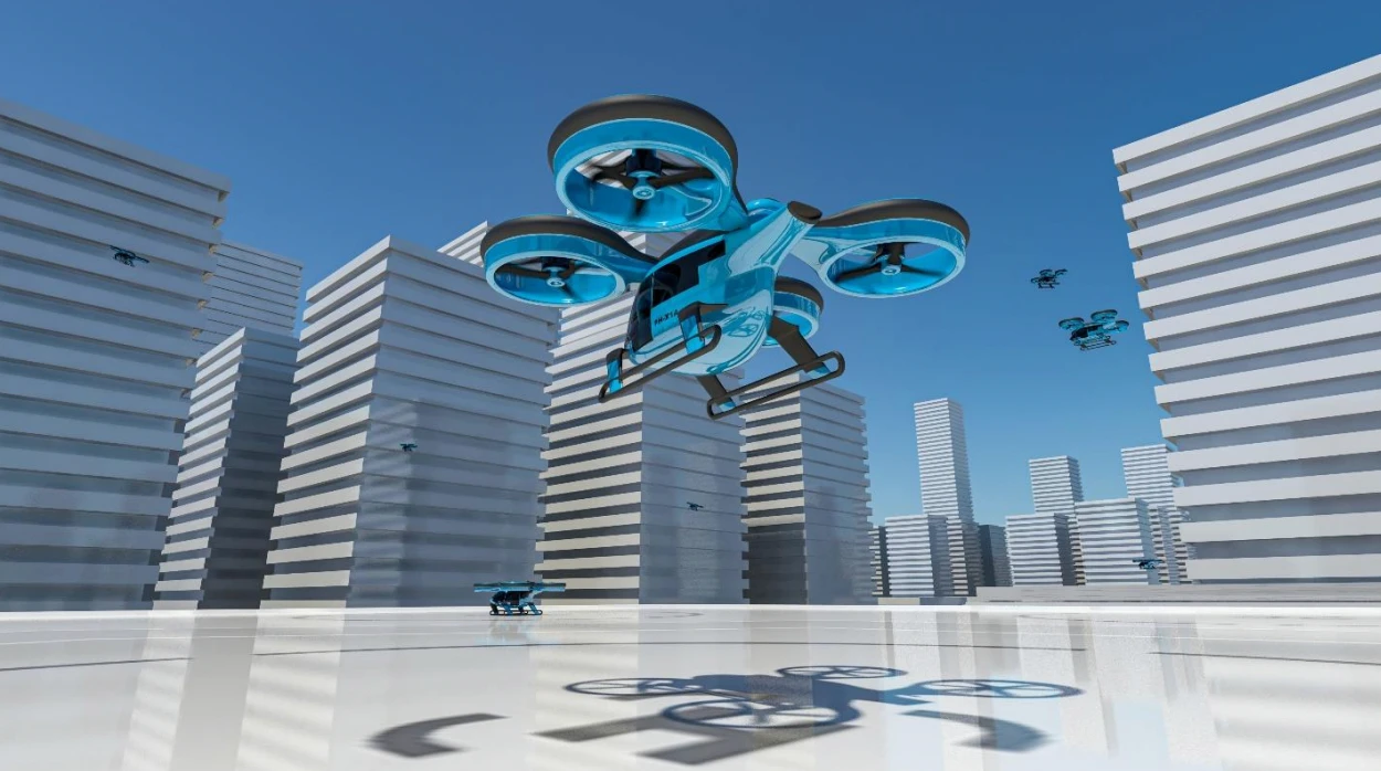
In just a few years, urban air mobility will be a reality, letting people travel conveniently in a way more suited to cities and their residents. Integrating these big future drones safely into our urban airspace requires a lot of coordination and a great deal of testing. Within the next few months, the European project AMU-LED will carry out several demonstration flights in urban environments in the United Kingdom, the Netherlands and Spain.

What if the future were to have ambulances transporting patients and critical medicines by air? What if firefighters could tackle fires safely and efficiently without putting human lives in danger? A future where people can travel faster and more efficiently from point to point, with better and optimised services for cities and their residents. That future is not a mere vision, it is a reality that will come to us in a matter of years: Urban Air Mobility (UAM). UAM is a transformational mobility concept for urban areas, using various types of drones to perform any type of mission that aims to improve the welfare of individuals and organisations.


U-space

One of the key enablers for UAM is U-space, an air traffic management framework to enable the safe and secure integration of drones. Just like the air traffic management system for general aircraft, U-space will ensure that drone operations are carried safely and efficiently. However, the system will be more automated than current air traffic control, with less human interaction and the capacity to handle more flights simultaneously. U-space can be defined as a set of specific services and procedures designed to ensure safe and efficient access to airspace for a large number of drones that embody high levels of digitalisation and automation.


Scenarios in urban environments

A lot of work has been put into developing U-space and UAM through research and innovation projects and technological developments. One of these initiatives is the AMU-LED project, a very large-scale demonstration (VLD) project funded by the SESAR Joint Undertaking under the European Union’s Horizon 2020 research and innovation programme. AMU-LED will demonstrate the safe integration of manned and unmanned aircraft through the deployment of U-space, with the ultimate goal of realising increasingly sustainable smart cities. This will be done by performing flight demonstrations with various scenarios, situations and use cases in urban environments.

In these demos, the project will use large electrical Vertical Take-off and Landing (eVTOL) platforms for passenger and cargo transport, combined with smaller Unmanned Aerial Systems (UAS) performing delivery of goods and medical supplies, surveillance or support for emergency services.


Objectives of AMU-LED

The project started two years ago in January 2020 with two main objectives of the project to demonstrate the safe interaction of UAM with other airspace users and to demonstrate safe UAM flight. After thorough preparation the flight demonstrations that will take place within AMU-LED can be considered as the final product of the project, putting into practice the concept of operations, use cases, scenarios, system architecture and the U-space system that will be defined in the project.

“After having carried out an impressive amount of work, where our consortium devised and implemented cutting edge concepts of operations for UAM, prepared futuristic yet round the corner use cases such as air commute shuttle or last-mile parcel delivery, and integrated innovative unmanned traffic management services, at last we are ready for take-off”, clarifies Pablo Menéndez-Ponte Alonso, project leader UTM of NTT DATA Spain that coordinates the European consortium of 17 different entities that take part in the AMU-LED project. “Cranfield is our first although essential demonstration, as it will allow us to understand the readiness of this technology by confronting the actual challenge.”

Eventually there will be seven demonstrations in total, taking place throughout summer of 2022, in Cranfield (UK), Amsterdam (NL), Enschede (NL), Rotterdam (NL), and Santiago de Compostela (SP).


Exchange of information

The variety in locations allows the project to test and demonstrate several relevant aspects in different ways, for instance assessing the most efficient way to exchange information between actors (such as the drones, their pilots and the air traffic management system). The project will test two different concepts for distributing relevant data: a centralised and a decentralised architecture. The decentralised architecture will be tested in Cranfield, Enschede and Rotterdam, and the centralised architecture will be tested in Amsterdam and Santiago de Compostela.

The information to be exchanged concerns all kinds of data, e.g. strategic and tactical information prior to and during the flight, tracking data (real-time information about the position of the drone), advisory tactical deconfliction service (information to avoid any conflicts prior to the flight and during the flight), and weather and CNS (Communication, Navigation and Surveillance) data.


What can be expected during the demonstrations?

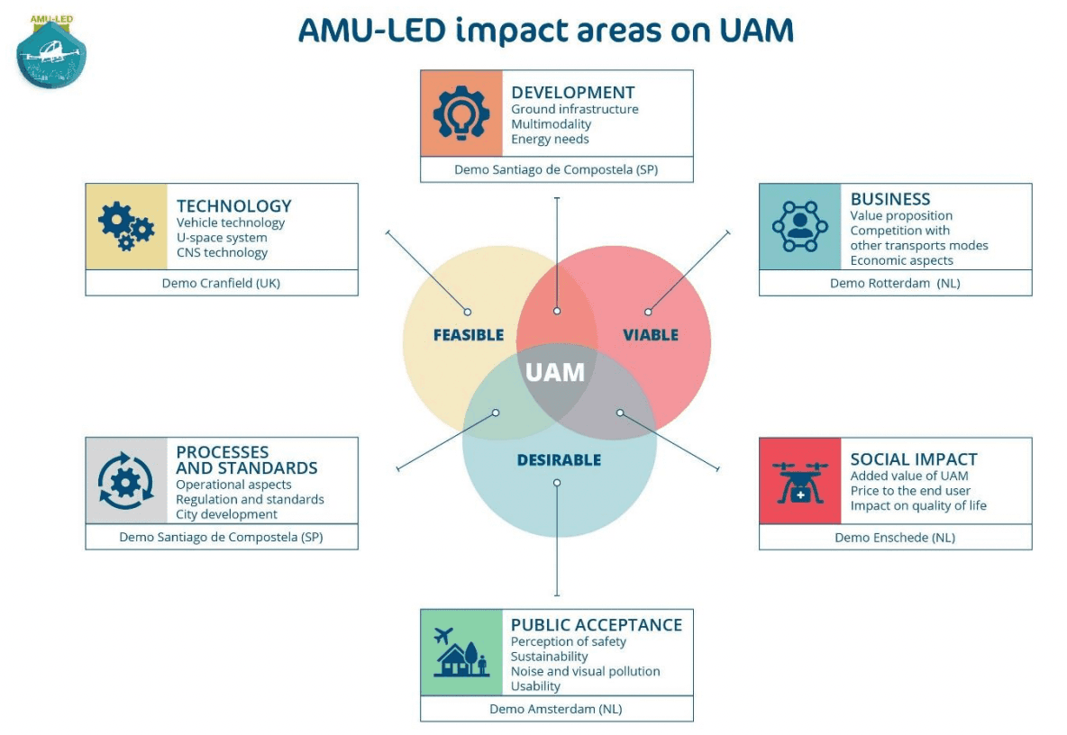
Additionally, as U-space and UAM are still concepts that are under development, AMU-LED followed the three pillars of innovation – feasibility, viability and desirability, to ensure that the demonstrations cover the bases for an effective implementation of UAM.

In June the demonstrations start with the feasibility case in Cranfield, proving the readiness of the AMU-LED solution, technologies, and systems. These tests are led by Cranfield University, and will take place at Cranfield Airport, a unique facility which has its own Air Navigation Service Provider and air traffic controllers, and its own pilots and aircraft. This demonstration will be a prerequisite for the subsequent demonstrations, proving that the AMU-LED solution is ready and safe to be tested in more complex environments. A second part of the Cranfield demonstration will take place in September.

After proving the feasibility of the AMU-LED solution, in August the project will continue testing the desirability of its solution in Amsterdam and Enschede, focusing on public acceptance and social impact.

In Amsterdam, the tests are led by the Royal Netherlands Aerospace Centre (NLR) and will take place in the heart of the city, at the Marineterrein. Using a focus group to gather data, the team will perform various flight demonstrations, testing different aspects of U-space and certain public acceptance indicators such as noise nuisance, perceived safety, trust in the technology, privacy concerns or visual pollution. Mitigation measures for the concerns raised by the focus group will be proposed on the basis of the data gathered.

Enschede will follow, demonstrating the social impact of UAM. Space53, a test and innovation centre for unmanned systems, is in charge of this demonstration, which will take place between the Space53 location at Technology Base and Twente Airport, and the city of Enschede. Showcasing various socially relevant use cases such as medical delivery, firefighting or police surveillance, this demonstration will prove the social impact that UAM will create when implemented.

In Rotterdam, the economic viability of UAM will be demonstrated also in August. This test is being coordinated by AirHub and will take place in the port area of the city. It will be done in collaboration with the Port of Rotterdam Authority, which wants to investigate the viability of transporting ships’ crews directly from the vessel to the hotel. Other use cases will be showcased as well, flying different UAVs and VTOL aircraft.

The city of Santiago de Compostela will host the final demonstration of AMU-LED, where all the previous aspects – feasibility, viability and desirability – come together in a big final show. Coordinated by the technology centre ITG – Fundación Instituto Tecnológico de Galicia the demonstration will focus on the correct implementation of all the aspects in urban environments, as the final showcase of how U-space can enable Urban Air Mobility. This will be demonstrated in September and in October.

Throughout these demonstrations, the project team will gather data about the various aspects being tested, which will then be analysed. This will let the project draw up results for the further development of U-space, providing information about the most efficient way for U-space to enable UAM, providing a safe, effective and viable solution for smart cities.

This project has received funding from the SESAR Joint Undertaking (JU) under grant agreement No 101017702. The JU receives support from the European Union’s Horizon 2020 research and innovation programme and the SESAR JU members other than the Union.