Stephan van Vuren

Stephan van Vuren

The Evolution of Drone as First Responder: From Rooftop Pilots to BVLOS Drone-in-a-Box Operations

AirHub's Drone Operations Center showing a Custom Session with a DJI Dcok 3 next to it

Drone as First Responder (DFR) programs are transforming the way emergency services respond to incidents. What began as an experimental practice with pilots stationed on rooftops in the United States has now evolved into sophisticated, remotely operated networks using drone-in-a-box (DiaB) systems. This shift has not only improved response times but also reshaped how we approach the integration of unmanned systems into regulated airspace.

The Origin of DFR

The first DFR programs took shape in the U.S., where police departments began deploying drones from station rooftops or nearby locations to rapidly respond to 911 calls. These drones provided situational awareness before officers arrived on-scene, supporting safer and more efficient decision-making. These early deployments were still operated by pilots within visual line-of-sight (VLOS), typically stationed near the take-off location.

Scaling with Drone-in-a-Box Systems

As the technology matured, these programs expanded in scale and complexity. Drone-in-a-Box systems now enable fully remote operation, where a drone is housed in an automated docking station, ready to be dispatched within seconds. This opens up the ability to operate DFR programs 24/7 across multiple locations, even with limited personnel.

These systems are increasingly integrated with Computer-Aided Dispatch (CAD) systems, allowing drones to be automatically dispatched to incident locations as soon as an emergency call is registered. The result is a dramatic reduction in response time and enhanced situational awareness for first responders.

Regulatory Landscape: BVLOS and Atypical Airspace

The rise of DiaB systems introduces new regulatory challenges. Since the pilot is no longer physically co-located with the drone, these operations inherently fall under Beyond Visual Line-of-Sight (BVLOS) rules. BVLOS operations require significant additional mitigations due to the increased operational risk.

Europe: Atypical Airspace and Operational Mitigations

In Europe, regulators often allow DFR operations under SORA-based frameworks, particularly in Atypical Airspace. This means the operation is conducted in areas that are naturally shielded from other airspace users, such as:

  • Close proximity to buildings or infrastructure

  • Restricted or segregated airspace

  • Controlled airspace with ATC coordination ensuring separation from manned aviation

Until a standard for Detect and Avoid (DAA) is fully defined, BVLOS operations are generally restricted to these kinds of environments. Additional mitigations include:

  • Using dynamic population density data

  • Integrating parachutes and FTS that comply with MoC 2512 and MoC 2511

  • Rigorous remote pilot training and emergency procedures

  • Technical validation of the operational volume (e.g. C2-link integrity, electromagnetic interference, etc.)

United States: Altitude-Based DAA Requirements

In the U.S., a similar pattern is emerging:

  • BVLOS operations below 200 feet AGL often do not require DAA systems

  • BVLOS operations up to 400 feet AGL typically require DAA capabilities

To meet these requirements, operators employ technologies such as:

  • ADS-B receivers to detect manned air traffic

  • Drone detection systems to identify nearby unmanned traffic

  • Integration of DFR systems with UTM services and airspace awareness tools

Full Airspace Awareness: Combining Drone Enablement and C-UAS

To support BVLOS safety and compliance, many DFR programs are now combining Drone-in-a-Box technology with counter-UAS (C-UAS) systems. This allows for:

  • Detection of non-cooperative drones

  • Enhanced awareness of local air traffic

  • Real-time deconfliction for safe mission execution

At AirHub, we are actively integrating our platform with systems such as SafeSky and various drone detection technologies to provide a full airspace picture for DFR operations.

Public vs. Commercial Operators: A Regulatory Divide

It's important to note that state operators (e.g. police departments) in the EU often benefit from more flexible regulatory conditions. In some member states, public safety agencies can conduct BVLOS operations in Class G airspace without DAA, provided they operate under state exemption rules.

On the other hand, commercial security companies are still required to operate in Atypical or segregated airspace and adhere strictly to SORA and EASA regulations. Until a harmonised DAA standard is introduced, this distinction is likely to remain.

How AirHub Supports DFR Operations

Whether you are a public agency or a commercial security provider, AirHub offers full-spectrum support for DFR programs:

Consultancy:

  • SORA application and documentation (ConOps, OM, ERP, etc.)

  • Strategy support and regulatory coordination

  • Stakeholder engagement and training programs

Software:

  • AirHub Drone Operations Center (DOC) for mission planning, real-time operations, and compliance

  • Integration with drone detection and airspace awareness tools

  • Risk assessment and checklist functionality

  • Secure Data Mode, encrypted 4G service and SSO for privacy and access control

Final Thoughts

Drone as First Responder is no longer a future concept - it is a rapidly scaling reality. With the right technologies and regulatory strategies in place, DFR can drastically enhance public safety, security, and situational awareness. At AirHub, we are proud to support this evolution by delivering both the tools and expertise needed to make it work.

Interested in starting or scaling a DFR program? Contact our team to explore what is possible.
Ready to see AirHub in action?

Book a demo and find out.

Related articles

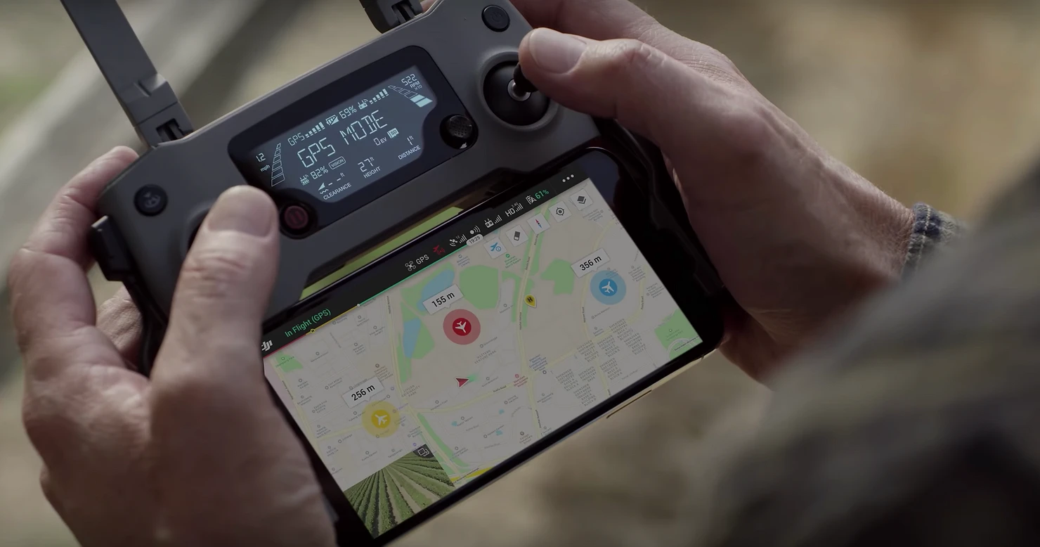
A DJI controller with AirHub's Ground Control app

Content

Specific Operations Risk Assessment for Drone Operators

What is a SORA risk analyses and how can it help you in setting up an Operating Manual for your drone operation in the Specific Category?

The Specific Operations Risk Assessment (#SORA) was developed by JARUS (the Joint Authorities for Rulemaking on Unmanned Systems) to provide drone operators a methodology for the risk assessment required to apply for an authorization to operate an Unmanned Aircraft System (#UAS) within the specific category.

The SORA proposes risk barriers to prevent the operation from going out of control and provides harm barriers in case the operation does get out of control (e.g. an emergency response plan). The SORA process starts with defining an operational volume by the operator in which the drone operation takes place. This operational volume is related to airspace adjacent to it and the surrounding area on the ground. The SORA includes both a Ground Risk Model and an Air Risk Model to determine risks to the surrounding area and the adjacent airspace, and to propose mitigating measures that can decrease those risks.

The SORA provides drone operators with the risk assessment methodology required to support the application for an authorization of a drone operation in the Specific Category.

In this article we will tell you more about the methodology behind the SORA and how this can help you set up an Operating Manual for your drone operation.


The Concept of Operations (ConOps)

The first step in the SORA process is describing the Concept of Operations (#ConOps) for the drone operation that you want to carry out. This ConOps requires you to collect and provide sufficient technical, operational and human information related to the intended use of the UAS. The ConOps should not only be a description of your operation but also provide insight into the operational safety culture at the organisation.

Basically you will need to describe the who's, what's and where's of the operation that you intend to carry out. For this you will need information about the drone and supporting equipment that will be used, you will need to know who will pilot the drone (and what his/her qualifications are), how the organisation will make sure that the operation is conducted safely and where the operation will take place (e.g. the airspace classification and the area that will be overflown).


Determining the Ground Risk Class (GRC)

The UAS ground risk relates to the unmitigated risk of a person being struck by the drone (in case of loss of control) and is represented in the SORA by eleven Ground Risk Classes (#GRC). The initial GRC is derived only from the dimensions and kinetic energy of the drone, the type of operation (#VLOS or #BVLOS) and the operational scenario (operations over an unpopulated or populated area, if the area is controlled or if the area includes a gathering of people).

The unmitigated risk of a person being struck by the UAS can be controlled and reduced by means of mitigations. This can, for example, be done by having an effective Emergency Response Plan (#ERP) in place. It is also possible to reduce the GRC by the limiting the effect of the ground impact of the drone by installing an emergency parachute. A third option is to have effective technical containments in place (e.g. active geofencing).

Each risk mitigation (or lack off) provides the you with a factor (+1 to -4) that can be added to the initial GRC to determine the final Ground Risk Class. When the final GRC is determined, the next step is to look at the air risks for the operation.


Determining the Air Risk Class (ARC)

The Air Risk Class (#ARC) is a generalised qualitative classification of the rate at which a drone would encounter a manned aircraft in a typical civil airspace. It provides an initial indication of the collision risk for the airspace, before mitigations are applied. The ARC can found by answering questions in the SORA flow chart about the altitude of the operation, if the operation is in controlled or uncontrolled airspace, if the operation takes place near an airport and if urban or rural areas are overflown.

The flow chart will tell the you what the initial ARC (A - D) is for the intended operation. However, the ARC is a generalised classification, so you - the operator could - consider that the qualification is too high for the conditions within the intended operational volume. If this is the case you can apply strategic and tactical mitigations to lower the ARC.

Strategic mitigation generally consists of procedures and operational restrictions aimed at mitigating risk by reducing the drones encounter rate, or time of exposure, prior to take-off. Strategic mitigations are divided between mitigation which can be controlled by the operator (strategic mitigation by operational restrictions) and those which cannot (strategic mitigation by structures and rules).

Tactical mitigation generally consists of mitigations that are applied after takeoff and take the form of a “mitigating feedback loop.” A mitigating feedback loop is a dynamic system employed to reduce the rate of collision by continuously modifying the geometry and dynamics of aircraft in conflict in an airspace, based on updated aircraft conflict information such as air traffic control (#ATC) traffic alert and collision avoidance system (#TCAS), unmanned traffic management (#UTM and See and Avoid (VLOS).

The Air Risk Class can be reduced by applying strategic and tactical mitigations.

After applying the strategic and tactical mitigations, the final ARC can be determined. Based on the final ARC objectives can be formed to prevent an infringement of the adjacent airspace next to the operational volume. The finial ARC in combination with the final GRC will also determine the Specific Assurance and Integrity Levels based on which Operational Safety Objectives are formed.


What are SAIL and OSO?

Specific Assurance and Integrity Levels (#SAIL) is the chosen parameter in the SORA methodology to consolidate the ground and air risk analysis. The level of confidence represented by the SAIL is not quantitative but instead corresponds to objectives that need to be complied with, descriptions of the activities that might support the compliance with those objectives and evidence to indicate the objectives have been satisfied.

Based on the SAIL (levels I - VI) Operational Safety Objectives (#OSO) are determined for barriers and mitigations to different threats, such as a technical issue with the UAS, a deterioration of external supporting systems, human error and adverse operating conditions. These OSO's basically describe the requirements for the operators organization, the drone and the pilot.

For the pilot requirements will be set on the knowledge and skill-levels he has to possess. These can be obtained by taking the right theoretical and practical drone training. Having the right drone and equipment is crucial for conducting a safe operation, the OSO also describe the requirements for the technical assessment of the drone, equipment and service. The organisation itself needs a SORA compliant Operating Manual to have the right procedures in place to safely and efficiently perform its drone operations.


Writing a SORA compliant Operating Manual

A professional Operating Manual is essential in setting up a safe and efficient drone operation. At AirHub we have written Operating Manuals for many different organisations in various industries. And although every organisation and drone operation is different, we have identified a number of need-to-haves for a SORA compliant Operating Manual.

A professional Operating Manual is essential to setting up a safe and efficient drone operation.

The first requirement is to make sure that your manual is properly structured to clearly distinguish general information from your operating procedures and other sections. At AirHub we use a format derived from traditional aviation manuals for this. It is also important to clearly describe the organisation behind your flight operation and the assigned responsibilities. A third requirement is to provide enough technical information about the drones, equipment and services used for your operation and maintenance requirements that apply to it.

The core of you operating manual will be the procedures that have to be applied by your personnel. It is very important to develop clear and easy to use standard operating procedures (#SOPs) for all actions from flight planning to post flight data processing. You will have to make sure that all mitigating measures stemming from your SORA analyses are incorporated in your normal, abnormal and emergency procedures.

The last requirement is to provide your personnel with all documentation needed to perform a mission. Make sure they have easy acces to all checklists, forms, etc. A professional Drone Operations Management System will save you lots of time and money with this.


How AirHub can help

At AirHub we have guided many organisations across various industries with setting up a safe, efficient and compliant drone operation. Contact us to take advantage of the experience and expertise of our consultants. They will guide you in applying the SORA risk analyses methodology and in setting up an operating manual specific to your operation. And with our AirHub Drone Operations Management platform you will be able to gain a comprehensive insight into your drone operation.

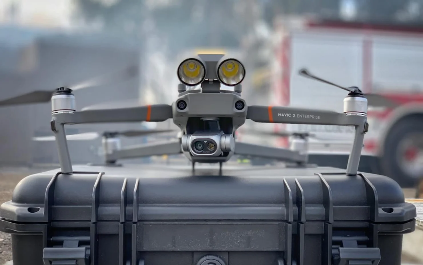
An enterprise drone with spotlight attachment on its carrying case

Content

DJI Mavic 2 Enterprise - Drone Starter Package

Save time and money by getting the right drones, tools, software and more with our Drone Starter Packages specifically composed for your type of operation.

Setting up a professional drone program at your company is no easy task. What is the right drone for the job? Which #software do we use to process the data? How do we stay compliant with national and local regulations? We will help you answer these questions and get an instant return on investment on your drone program.


The DJI Mavic 2 Enterprise

Whether you want to perform search and rescue missions, fight fires or inspect industrial assets such as bridges power lines or cell towers, the DJI #Mavic 2 Enterprise is the perfect companion for almost any mission. The standard version of the Mavic 2 Enterprise comes with a powerful 12MP camera with 2x optical and 3x digital zoom that is great for close up inspection purposes. The Mavic 2 Dual is equipped with an optical and FLIR thermal camera that can be used for both visual and thermal inspections. Both aircraft can also be fitted with optional accessoires such as a spotlight, a speaker and a beacon. The Mavic 2 Enterprise series aircraft are equipped with advanced safety features such as ten sensors that prevent a collision with objects and comprehensive data encryption.

At AirHub we will provide you with the version of the Mavic 2 Enterprise that exactly suits your needs and deliver it with a professional tablet including our Drone Operations Management software. We will also make sure you have all the additional accessoires and equipment you need to perform consistent, low risk operations. And all our M2E drones come with a 12 moth replacement warranty and the possibility to enjoy our maintenance service, so you will never have to worry about operational availability.

Choosing the right drone is essential for the succes of your operation.


Software that matches the hardware

By using the right processing software, you can turn the #data you have captured into actual value. It does not matter if you are in #agriculture, #construction or #inspection. We will provide you with the third-party software needed to create #3D models, high resolution maps, #NDVI analyses and more. And with the AirHub Drone Operations Management Software you will be able to safely and easily get airspace intelligence, plan and track your flights with #UTM connectivity and manage your fleet, teams and maintenance.

Use AirHub to fly safe and stay compliant with national regulations.


Get trained and get certified

Buying the right drones and software is just the beginning. In order to create a safe, efficient and compliant drone operation you want to provide your crews with comprehensive ground and flight training on your standard operating procedures (#SOPs) and flight scenarios. AirHub will guide you in this with setting up an Operations Manual and by assisting you with the application for the necessary #waivers and #certificates for your operation. Once your operation is up and running we will also be there to support you if any questions arise. As an operations manager you can use the AirHub Drone Operations Management platform to schedule maintenance, check the currency of your crew, provide them with the necessary documentation and much more.


How AirHub can help

At AirHub we have guided many organisations across various industries with setting up a safe, efficient and compliant drone operation. Contact us to take advantage of the experience and expertise of our consultants and trainers. They can help you select the right drones and software, write your standard operating procedures and operations manual and set up your training program and company certification. And with our AirHub Drone Operations Management platform your managers will be able to gain a comprehensive insight into their flight operation.

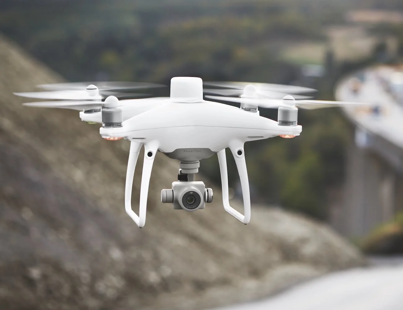
A DJI Phantom 4 with the new RTK module on top making it 100x more accurate than GPS

Content

DJI Phantom 4 RTK - Drone Starter Package

Save time and money by getting the right drones, tools, software and more with our Drone Starter Packages specifically composed for your type of operation.

Setting up a professional drone program at your company is no easy task. What is the right drone for the job? Which #software do we use to process the data? How do we stay compliant with national and local regulations? We will help you answer these questions and get an instant return on investment on your drone program.


The DJI Phantom 4 RTK

If you want to perform highly accurate mapping mission, the DJI #Phantom 4 RTK is the tool you need. The #RTK module - in combination with the optional D-RTK GNSS Mobile Station - provides real-time, centimeter-level positioning data for improved absolute accuracy on image metadata while requiring fewer ground control points. A redundant GNSS module is installed to maintain flight stability in signal-poor regions such as dense cities. Combining both modules, the Phantom 4 RTK is able to optimize flight safety while ensuring that the most precise data is captured for complex surveying, mapping and inspection workflows.

The OcuSync Transmission System provides stable and reliable HD image and video transmission at distances of up to 7 km, great for mapping larger sites. The new TimeSync system continually aligns the flight controller, camera and RTK module and hereby ensures that each photo uses the most accurate metadata and fixes the positioning data to the center of the 20 megapixel CMOS camera sensor – optimising the results from photogrammetric methods and letting the image achieve centimeter-level positioning data.

At AirHub we can provide you with a ready to fly Phantom 4 RTK and optional D-RTK GNSS Mobile Station and deliver it with a professional tablet including our Drone Operations Management software. We will also make sure you have all the additional accessoires and equipment you need to perform consistent, low risk operations. And all our M2E drones come with a 12 moth replacement warranty and the possibility to enjoy our maintenance service, so you will never have to worry about operational availability.

Choosing the right drone is essential for the succes of your operation.


Software that matches the hardware

By using the right processing software, you can turn the #data you have captured into actual value. It does not matter if you are in #agriculture, #construction or #inspection. We will provide you with the third-party software needed to create #3D models, high resolution maps, #NDVI analyses and more. And with the AirHub Drone Operations Management Software you will be able to safely and easily get airspace intelligence, plan and track your flights with #UTM connectivity and manage your fleet, teams and maintenance.

Use AirHub to fly safe and stay compliant with national regulations.


Get trained and get certified

Buying the right drones and software is just the beginning. In order to create a safe, efficient and compliant drone operation you want to provide your crews with comprehensive ground and flight training on your standard operating procedures (#SOPs) and flight scenarios. AirHub will guide you in this with setting up an Operations Manual and by assisting you with the application for the necessary #waivers and #certificates for your operation. Once your operation is up and running we will also be there to support you if any questions arise. As an operations manager you can use the AirHub Drone Operations Management platform to schedule maintenance, check the currency of your crew, provide them with the necessary documentation and much more.


How AirHub can help

At AirHub we have guided many organisations across various industries with setting up a safe, efficient and compliant drone operation. Contact us to take advantage of the experience and expertise of our consultants and trainers. They can help you select the right drones and software, write your standard operating procedures and operations manual and set up your training program and company certification. And with our AirHub Drone Operations Management platform your managers will be able to gain a comprehensive insight into their flight operation.