Coming Soon

Coming Soon

Drone Detection

Monitor and respond to drone activity with full situational awareness.

Drone Detection

Immediate Situational Awareness

Visualize all detected drones, pilots, and manned aircraft on a single map, monitor their flight paths in real time, and instantly assess threat levels based on proximity, heading, and geofence status.

Drone Detection

Take Direct Action

Receive instant alerts when a drone enters restricted airspace, with automated emails or text messages linking directly to the live dashboard so your team can assess the situation and take immediate action.

Drone Detection

Analyze Activity and Uncover Trends

View all detected flights across days, weeks, or months, filter by drone type or risk level, and explore summary statistics like average altitude, flight duration, and total detections over time.

Drone Detection

Inspect Every Detected Flight in Full Detail

Select any detected flight to view its full profile - including drone ID, threat level, flight path, altitude, duration, and pilot location - and replay the event on the map with all relevant geofences and nearby aircraft.

Drone Detection

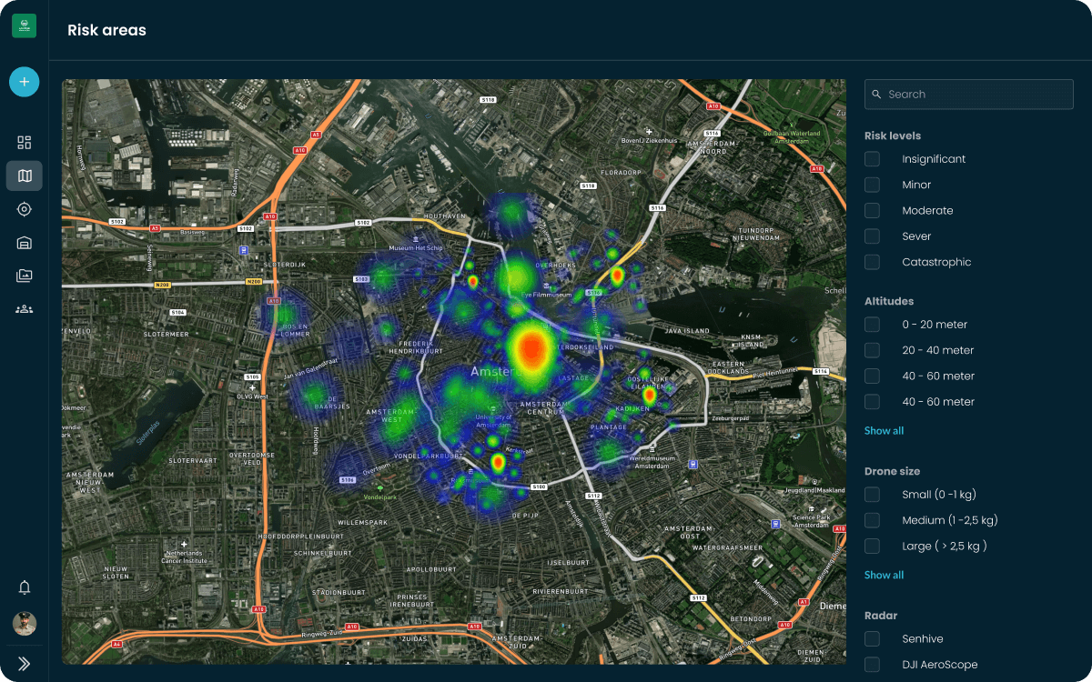
Identify Hotspots and High-Risk Zones

Use the interactive heatmap to visualize where drone activity is most frequent or critical, filtered by time, altitude, drone type, and detection system - helping you pinpoint patterns and adjust your security posture.

Drone Detection

Manage and Configure Your Detection Network

View and control all connected drone detection systems in one place, adjust monitoring zones, set altitude limits, manage whitelists, and visualize each system’s coverage directly on the map.

Live Airspace

Instantly view all detected drones and pilots on a single real-time map.

Fleet management overview

Flight Analysis

Explore detailed flight data and replay detected drone events on the map.

Time

15:45

Speed

4 km/h

Altitude

22.4 m

Distance home

32.0 m

Battery

82%

Battery

24

High Risk Area
High Risk Area
Mapview with Waypoints

Automated Notfications

Get instant alerts when drones enter restricted airspace or breach rules.

Get instant alerts when drones enter restricted airspace or breach rules.

Get instant alerts when drones enter restricted airspace or breach rules.

Amount of flights

Month

Year

Week

200

150

50

0

100

20

may

21

may

22

may

23

may

24

may

25

may

26

may

Amount of flights

Month

Year

Week

200

150

50

0

100

20

may

21

may

22

may

23

may

24

may

25

may

26

may

Amount of flights

Month

Year

Week

200

150

50

0

100

20

may

21

may

22

may

23

may

24

may

25

may

26

may

200

150

50

0

100

20

may

21

may

22

may

23

may

24

may

25

may

26

may

Radar Management

Monitor and configure each radar’s coverage, settings, and geofences.

Monitor and configure each radar’s coverage, settings, and geofences.

Monitor and configure each radar’s coverage, settings, and geofences.

Counter Drone Gear DJI Aeroscope
Counter Drone Gear Robin Radar
Counter Drone Gear Senhive

Heat Maps

Visualize high-risk zones with heatmaps filtered by drone type or time.

Visualize high-risk zones with heatmaps filtered by drone type or time.

Visualize high-risk zones with heatmaps filtered by drone type or time.

User Interface of showing risk areas

Be the first to try our new drone detection features

Sign up for updates and Get Early Access.

Counter Drone Monitor
User Interface Counter Drone Threats
User Interface Counter Drone Monitoring
User Interface Counter Drone Jamming
User Interface Counter Drone Risk areas
User Interface Counter Drone Threats
User Interface Counter Drone Monitoring
User Interface Counter Drone Jamming
User Interface Counter Drone Risk areas